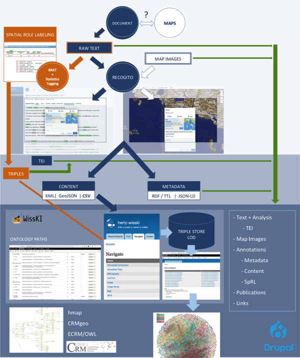
Historical Spaces in Texts and Maps - A cognitive-semantic analysis of Flavio Biondo's Italia Illustrata
Texte und Karten bilden Räume nicht einfach ab, sondern sie schaffen sie. Das Projekt untersucht am Beispiel von Flavio Biondo's "Italia Illustrata" aus dem 15. Jahrhundert, welche Räume diese literarische Beschreibung von Italien entwirft, indem sie topographische und historische Angaben seit der Antike in einer spezifischen Syntax verbindet. Die kognitiv-semantische Analyse des Textes geht mit der Untersuchung historischen Kartenmaterials einher, das das historische Raum-Wissen visuell aufbereitet und speichert.
Texts and maps don't just describe or illustrate places – they create them. With a mid-fifteenth-century text, Flavio Biondo's Italia Illustrata, as its focus, this project is an investigation into the spaces a literary account of Italy conceptualizes by creating a specific syntax that conflates topographical and historical facts dating back to antiquity. The cognitive-semantic analysis of Biondo's text goes hand-in-hand with a study of historical cartographic sources that store and communicate early geoscience in a visual form.
Repositorium der Forschungsdaten - Repository of Research Data

Forschungsdaten-Repositorium | Research Data Repository <<< ZUGRIFF | ACCESS ![]()
---------------------------------------------------------------------------------------------------------------------------------------------------
Günther Görz, Chiara Seidl
Bibliotheca Hertziana, Max-Planck-Institut für Kunstgeschichte, Rom und FAU Erlangen-Nürnberg
Danksagung / Acknowledgement: Mark Fichtner, Sarah Wagner, Germanisches Nationalmuseum Nürnberg, für exzellente technische Unterstützung / for excellent technical support